


 Express:


RIDE WITH TEAM ZUMO
The rugged zumo XT motorcycle navigator is built for adventure. Its ultrabright 5.5-inch display is glove-friendly, rain-resistant and shows you the adventurous way on and off the beaten path.
- See this super bright 5.5-inch display during day and night, and use it in any weather.
- From hands-free calling to inReach satellite communication, we've got rider safety in mind1.
- Life is full of twists and turns. Garmin Adventurous Routing takes you to them.
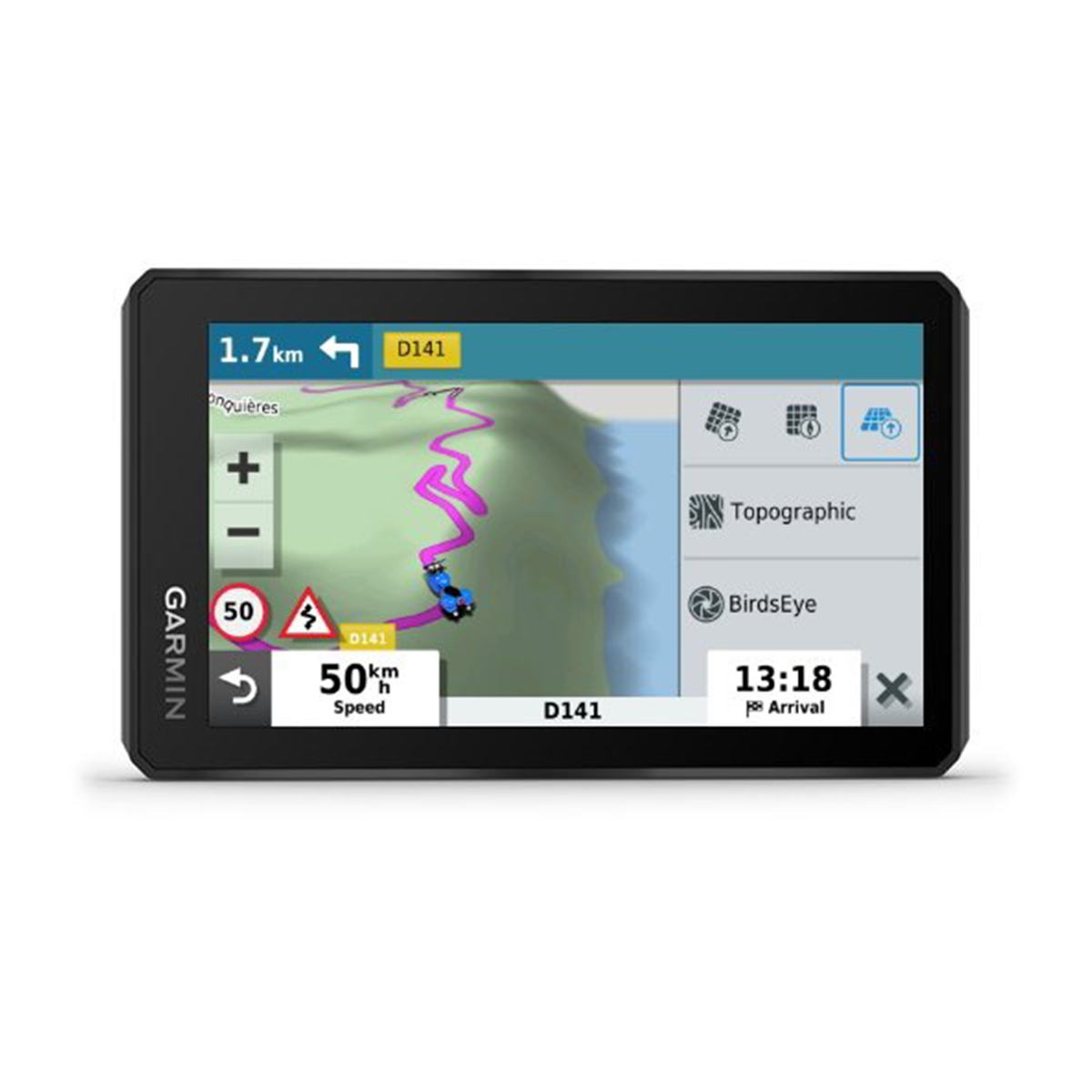
- Switch from EU maps to topographic maps to BirdsEye Satellite Imagery with just a tap.
- Track recorder remembers your best rides, so you don't have to.
- Keep your edge with rider alerts for hazards such as sharp curves along your route.
ULTRABRIGHT DISPLAY
- The 5.5-inch display is brighter than previous models and can be seen in any light. It's also glove-friendly with crisp HD resolution in landscape or portrait mode.
RUGGED BUILD
- Go confidently into every ride with a navigator that's built to withstand all kinds of weather (IPX7) and rough rides.
LASTING POWER
- With the backlight set at 100% brightness, the battery lasts up to 3.5 hours, and it can go up to 6 hours on regular settings. Or you can hard-wire to constant power for longer adventures.
BIRDSEYE SATELLITE IMAGERY
- You'll have access to global BirdsEye Satellite Imagery with direct-to-device downloads via Wi-Fi connectivity and no annual subscription.
PRELOADED ON-ROAD MAPS
- Be ready for the ride with preloaded street maps for all of Europe. Map updates included.
PRELOADED OFF-ROAD MAPS
- Adventurous riding is encouraged with preloaded off-road topographic maps.
SIMPLE MAP SWITCHING
- Quickly toggle between on-road maps, topographic maps and BirdsEye Satellite Imagery, so you can always have the perfect map for your ride.
GARMIN ADVENTUROUS ROUTING
- Turn straightforward rides into twisting, gnarly adventures by selecting your road preferences.
TRACK RECORDER
- Record your route by using the track recorder, and save or share it for future adventures.
SHARE YOUR FAVOURITE RIDES
- Easily send GPX files from your phone to your zumo XT, or share GPX files with fellow riders by using the Garmin Drive app.
TRIPADVISOR
- View TripAdvisor traveller ratings for hotels, restaurants and attractions along your route or near your destination.
SIGHTSEEING MADE EASY
- zumo XT includes iOverlander POIs and millions of popular places, thanks to Foursquare.
RIDER ALERTS
- Get alerts for hazards along your route, such as upcoming sharp curves, speed changes and more. You'll also be notified about upcoming safety cameras3.
MANAGE YOUR TRACKS AND ROUTES
- Easily manage4 and review routes, tracks and waypoints across your navigator, smartphone and computer by using the Garmin Explore app.
GARMIN REAL DIRECTIONS
- Get spoken turn-by-turn directions through your connected helmet or headset. They guide like a friend, using street names, store names and recognizable landmarks.
MUSIC
- Stream music from your smartphone through the zumo XT navigator, or play MP3 files stored on the navigator all to your connected helmet or headset.
HANDS-FREE CALLING
- With Bluetooth technology, you can make hands-free5 calls. When paired with the Garmin Drive app on your phone, you can view smart notifications right on your zumo display.
LIVE TRAFFIC AND WEATHER
- Access2 real-time traffic and weather, share routes with other riders, and get phone notifications via the Garmin Drive app.
INREACH PAIRING
- Pair zumo XT with a compatible inReach satellite communicator1 for two-way messaging, location sharing and, in case of emergencies, SOS capabilities.
INCIDENT NOTIFICATIONS
- If an incident occurs, a text message with location information is automatically sent to your predetermined contact2.
WIRELESS UPDATES
- Built-in Wi-Fi4 connectivity makes it easy to keep your maps and software up to date without using a computer. Onscreen cues show when new updates are available.
| PHYSICAL DIMENSIONS | WxHxD: 8.8 x 14.8 x 2.4 cm |
| DISPLAY SIZE | 12.1 x 6.8 cm; 5.5-inch diag (13.9 cm) |
| DISPLAY RESOLUTION | 1280 x 720 pixels |
| DISPLAY TYPE | Multi-touch, glass, high brightness HD colour TFT with white backlight |
| DUAL-ORIENTATION DISPLAY | YES |
| WEIGHT | 262 g |
| BATTERY TYPE | Rechargeable lithium-ion |
| BATTERY LIFE | Up to 6 hours (up to 3.5 hours at 100% backlight) |
| WATER RATING | IPX7 |
| DROP RATING | MIL-STD-810 |
| HANDLEBAR MOUNT (UP TO 1 | YES |
| PRELOADED STREET MAPS | YES |
| DATA CARDS | microSD card (not included) |
| 3-D BUILDINGS AND TERRAIN | yes (3-D Terrain only) |
| INTERNAL STORAGE | 32 GB |
| ABILITY TO ADD MAPS | YES |
| STORAGE AND POWER CAPACITY | yes (256 GB max microSD card) |
| INCLUDES MAP UPDATES | YES |
| DOWNLOADABLE SATELLITE IMAGERY | yes (BirdsEye) |
| GPS | YES |
| GLONASS | YES |
| GALILEO | YES |
| PRELOADED TOPOACTIVE EUROPE MAPS | YES |
| NAVIGATE-A-TRACK NAVIGATION | YES |
| GARMIN REAL DIRECTIONS LANDMARK GUIDANCE | YES |
| MILLIONS OF FOURSQUARE POINTS OF INTEREST | YES |
| TRIPADVISOR TRAVELLER RATINGS | YES |
| ROUTE SHAPING THROUGH PREFERRED CITIES/STREETS | YES |
| TRAFFIC UPDATES | Yes (with Garmin Drive app) |
| LANE ASSIST WITH JUNCTION VIEW (DISPLAYS JUNCTION SIGNS) | YES |
| BLUETOOTH CALLING | Yes (works with Bluetooth-compatible helmet, headset or smartphone; BLE capable) |
| SPEED LIMIT INDICATOR (DISPLAYS SPEED LIMIT FOR MOST MAJOR ROADS IN THE U.S. AND EUROPE) | YES |
| DRIVER ALERTS FOR SHARP CURVES, SCHOOL ZONES, RED LIGHT AND SPEED CAMERA WARNINGS AND MORE | YES |
| SMART NOTIFICATIONS VIA APP | YES |
| WI-FI MAP AND SOFTWARE UPDATES | YES |
| ACCESS TO LIVE SERVICES VIA APP | YES |
| GLOVE-FRIENDLY TOUCHSCREEN | YES |
| CONTROL MUSIC AND MEDIA FROM SMARTPHONE OR MP3 PLAYER | YES |
| SUNLIGHT READABLE AND WEATHER RESISTANT | YES |
| GARMIN ADVENTUROUS ROUTING | YES |
| RIDER ALERT WARNINGS FOR SHARP CURVES, HELMET LAWS, SPEED CAMERAS AND MORE | YES |
| PLANNED & DYNAMIC FUEL STOPS | YES |
| MOTORCYCLE OR POWERSPORTS SPECIFIC POINTS OF INTEREST FOR CYCLE REPAIR SERVICES, DEALERS AND MORE | YES |
| HELMET LAW NOTIFICATIONS | YES |
| ELEVATION PROFILE | YES |
| ROUND TRIP ROUTING | YES |
| SERVICE HISTORY LOG | YES |
| TRACK SUPPORT | YES |
| CUSTOM MAP SUPPORT | YES |
| TOPO MAP SUPPORT | YES |
| WIRELESS ANT+ TECHNOLOGY | YES |
| PAIR WITH COMPATIBLE INREACH DEVICES | YES |
| COMPATIBLE WITH GROUP RIDE TRACKER | YES |
| TRACK RECORDER (BREADCRUMBS) | YES |
| IOVERLANDER POINTS OF INTEREST | YES |
| ACSI, CAMPERCONTACT AND TRAILER'S PARK | YES |
| GROUP RIDE TRACKING | compatible with Group Ride Radio |
| GROUP RIDE UPDATE RATE | 5 seconds |
| COMPATIBLE WITH GARMIN EXPLORE APP | YES |